Advertisement
Grab your lab coat. Let's get started
Welcome!
Welcome!
Create an account below to get 6 C&EN articles per month, receive newsletters and more - all free.
It seems this is your first time logging in online. Please enter the following information to continue.
As an ACS member you automatically get access to this site. All we need is few more details to create your reading experience.
Not you? Sign in with a different account.
Not you? Sign in with a different account.
ERROR 1
ERROR 1
ERROR 2
ERROR 2
ERROR 2
ERROR 2
ERROR 2
Password and Confirm password must match.
If you have an ACS member number, please enter it here so we can link this account to your membership. (optional)
ERROR 2
ACS values your privacy. By submitting your information, you are gaining access to C&EN and subscribing to our weekly newsletter. We use the information you provide to make your reading experience better, and we will never sell your data to third party members.
Pollution
A local look at air pollution highlights inequalities within cities
High-resolution data on air quality are helping scientists and community groups understand and address disparities in pollution between neighborhoods
by Katherine Bourzac
June 20, 2021
| A version of this story appeared in
Volume 99, Issue 23

Credit: Adapted from Sally Pusede/Environ. Sci. Technol. | Levels of nitrogen dioxide in Houston vary widely. This map, made by overlaying a heat map (blue = lower NO2; red = higher NO2) of the pollutant over a satellite image, is from a study that showed that neighborhoods that are predominantly Hispanic have higher levels of NO2 than non-Hispanic, White neighborhoods.
When Cesunica Ivey moved to Southern California to start her lab at the University of California, Riverside, in 2018, one of the first things she did was meet with a local environmental advocacy group. An expert in air quality modeling and exposure, Ivey wanted to know what pollution issues the community was concerned about.
In brief
On average, people of color in the US live in places with poorer air quality than do White people. More-granular air quality measurement technologies involving ground-based sensor networks and pollution-monitoring satellites can find differences in air quality between neighborhoods. Researchers hope these technologies will allow people who reside in neighborhoods with poor air quality to attach hard numbers to their experiences and help identify and address health inequities. Activists and community leaders plan to use the data from these tools to help persuade policy makers and industry to support targeted pollution mitigation efforts to the neighborhoods that stand to benefit the most from them.
Ivey and a representative from the Center for Community Action and Environmental Justice drove around San Bernardino and Riverside Counties, and the representative pointed out many air quality problems. Ivey saw industrial facilities and heavy-duty trucking close to residential neighborhoods. She wasn’t just relying on her eyes. Ivey wore a particulate matter sensor, and she saw how the readings spiked when she got out of the car in different locations.
Two neighborhoods, both of which have majority-Hispanic-and-Latino populations, stuck out to her in particular. In Bloomington, she saw kids walking home from school down a road with no sidewalks while a dirt hauler careened by, letting off dust and diesel emissions. In Mira Loma Village, Ivey says, “I could have thrown a paper airplane from a residential neighborhood and hit the back of a warehouse.” Heavy-duty trucks idled near the neighborhood’s homes, and toys left outside were filmed with dark soot from traffic emissions.
“In Southern California, we’re all exposed to nasty air, but there are gradients within that,” Ivey says. Health-harming pollutants like nitrogen dioxide and particulate matter can be highly concentrated near where they are emitted but dissipate over larger areas.
Typical air quality assessments, which average readings over counties or even cities, tend to blur significant sources of exposure for people living or working on a particular block or in a particular neighborhood. These pollution hot spots can affect the health of the people who live or work near them, possibly leading to cardiovascular, lung, and other diseases and shortening residents’ lives.

In the US, historical redlining—racist housing, zoning, and loan policies—limited where people of color could live. Redlining pushed people of color to dwell in neighborhoods with poorer air quality, and this inequity persists to this day, Ivey says.
For example, one study found that in 2010, people of color in the US were 2.5 times as likely as White people to live in areas with NO2 levels above the World Health Organization’s guidelines for safety (Environ. Health Perspect. 2017, DOI: 10.1289/EHP959). Another study, published this April, showed that particulate matter polluters disproportionately affect people of color (Sci. Adv. 2021, DOI: 10.1126/sciadv.abf4491).
These disparities persist despite overall progress in the US in lowering the levels of harmful pollutants. Passed over 50 years ago, “the Clean Air Act has been so successful, but it has really only brought down air pollution over wide spatial scales,” says Susan Anenberg, an epidemiologist at the George Washington University. “It really has not addressed the disparity question.”
That’s what motivates scientists like Ivey and Anenberg, as well as community activists, to turn to more-granular air quality measurement technologies. These analytical tools include wearable sensors, networks of low-cost monitors installed on rooftops, and even an emerging network of pollution-measuring satellites, which could extend intracity air pollution monitoring around the world. Equipped with these technologies, researchers can map air pollution exposure within a city and then compare it with health data from neighborhoods to understand how air quality disparities affect specific communities. Activists and community leaders hope that collecting these data will allow people in these neighborhoods to attach hard numbers to their experiences and help them advocate for targeted pollution mitigation efforts.
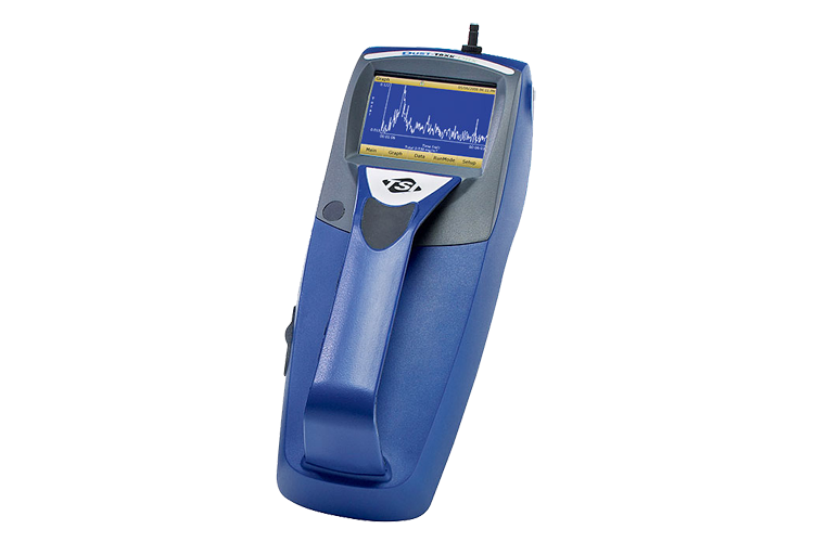
AIR QUALITY MONITORS
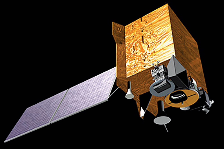
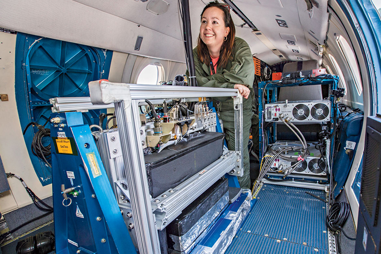
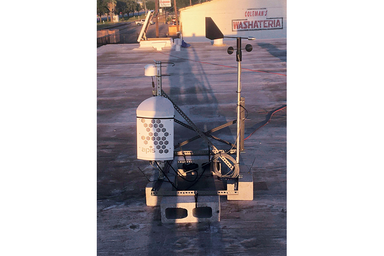
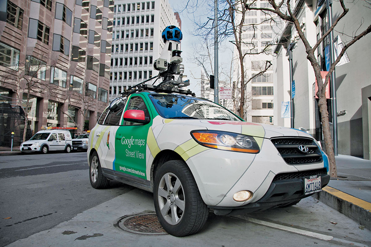
Combining data from multiple kinds of air quality monitors provides the highest-quality picture of air pollution within cities. Each of these measurement technologies has advantages and limitations.
Filling in the gaps
Juan Flores’s community in the Houston area experiences the effects of pollution disparities daily. Flores is the community air-monitoring program manager at Air Alliance Houston and lives in Galena Park, Texas, which lies along the Houston Ship Channel. “I’ve seen a lot over the years,” Flores says. “Explosions, you know, clouds from refineries. We get the bad emissions.”
To increase the monitoring of pollution in the area, earlier this year, the alliance installed three monitoring stations in Pasadena, which is also along the ship channel and abuts Houston, and Flores is expanding the network to other cities in the area. These monitoring stations include sensors that measure nitrogen oxides, ozone, particulate matter, and total volatile organic compounds.

One of the alliance’s goals is to fill in the gaps in the county’s monitoring network. Houston is the largest city in the US with no zoning rules. Pasadena—nicknamed Stinkadena—is the second largest. Because of this lack of zoning rules, “there are lots of conflicting land uses where schools and day cares and churches and hospitals are located in proximity to air pollution sources,” says Corey Williams, research and policy director at Air Alliance Houston.
“It’s mostly Black and Brown communities being affected” by these air pollution hot spots, Flores says. For example, Pasadena’s population is about 70% Hispanic or Latino, according to 2019 US Census Bureau estimates.
To enforce air quality standards under the Clean Air Act, the Environmental Protection Agency operates a network of regulatory monitors throughout the country. These monitors determine whether the ambient air in an area meets regulatory standards for six air pollutants: ground-level ozone, particulate matter, carbon monoxide, lead, sulfur dioxide, and nitrogen dioxide. State and county environmental agencies typically also operate air quality–monitoring networks to provide more detail. But all told, air quality monitoring is relatively sparse—which is why Air Alliance Houston and others feel the need to act. “We’re building an air-monitoring network so we can gather data to back up our suspicions that it’s polluted and we’re struggling,” Flores says. “We have to defend ourselves.”
Researchers are collecting finer-scale data with modeling studies, land use data, and increasingly, monitoring technologies with higher spatial and time resolution. And their work supports what Flores and others are experiencing in their neighborhoods.
In 2020, researchers led by Sally Pusede, an atmospheric chemist at the University of Virginia, performed a study that demonstrated the power of combining multiple air pollution measurement techniques to understand air quality disparities within a city—in this case, Houston. They combined demographic data from the US Census Bureau with air quality readings from a global NO2-monitoring satellite, which has a spatial resolution of 3.5 by 7 km, and from a NASA plane that flew over Houston in 2013. That plane, which took 21 flights over 11 days, was fitted with a visible and ultraviolet light spectrometer and took measurements with a spatial resolution of 250 by 500 m.
They found that neighborhoods where more residents are Black, Hispanic, and Latino have 37% higher levels of NO2 than neighborhoods where a majority of residents are non-Hispanic and White (Environ. Sci. Technol. 2020, DOI: 10.1021/acs.est.0c01864).
Pusede says the Houston study, in addition to illustrating inequities in Houston, validates the combination of these two remote-sensing technologies for studying air pollution variation within cities. Pusede is expanding this work to other cities, including Denver and New York City, covered by the same airborne NASA campaign.
Meanwhile, Laura Judd of NASA’s Langley Research Center and her team are planning another flight over Houston in September. “What we’ve found is, the finer spatial resolution you get, the more detail there is,” Judd says. “At 250 m, you can see real gradients that do exist, and those gradients are very dynamic. You see it come out of a smoke stack and 2 h later it’s 20 mi [32 km] downwind,” she says. Judd is excited about the possibility of higher-spatial-resolution data helping air quality scientists uncover previously unknown local sources, which can be challenging because of how rapidly pollutants like NO2 dissipate.
Increasing spatial resolution also helps elucidate the ties between pollutant exposure and health effects, says C. Arden Pope III, an epidemiologist at Brigham Young University. Researchers can collect health data for individual neighborhoods and then correlate that information with high-resolution air quality data to look for connections. For example, they can find increased incidences of heart disease in areas with elevated particulate matter levels. “Better exposure data lead to less biased estimates of the association between air pollution and health outcomes,” Pope says. “We don’t want to underestimate, or overestimate, the effects.”
In general, he says, studies that include multiple types of air pollution measurements—such as a combination of ground measurements and satellite observations—at higher spatial resolution have more statistical heft. They also tend to find stronger correlations between air pollution exposure, health effects, and mortality.
Pope says it’s not yet clear just how detailed air pollution data need to be to create the most accurate models possible. “Even if you knew exactly the pollution levels exactly where a person lives, that person goes to work, goes shopping,” he says. People don’t just breathe the air in their neighborhoods, so how granular do air quality data need to be before researchers face diminishing returns?
While epidemiologists are exploring these finer points, Pope says it’s clear that from a health perspective, “having more pollution in your neighborhood is a big deal.”
Air pollution and health
Many air pollutants are linked with adverse health effects. The three with the biggest health impacts are nitrogen dioxide (NO2), ozone (O3), and particulate matter (PM).
NO2
Sources: NO2 is a by-product of combustion. Its main sources are traffic emissions, especially those from diesel-fueled trucks. People who live and work near freeways and transportation hubs like ports and rail yards are exposed to more NO2 than the average person.
Impacts: The gas can irritate the respiratory system, causing asthma. NO2 exposure can increase susceptibility to respiratory infections.
O3
Sources: Ground-level O3 is a secondary pollutant, formed from reactions between nitrogen oxides and volatile organic compounds. These reactions are driven by heat and sunlight, so O3 tends to spike during the summer and where air stagnates, such as in inland valleys.
Impacts: O3 inflames people’s lungs, making it difficult to breathe, aggravating asthma and other respiratory conditions, and leaving people more vulnerable to infections.
PM
Sources: Inhalable particles are characterized not by their chemistry but by their size. PM2.5 particles are 2.5 μm in diameter or smaller; PM10 is 10 μm or smaller. PM can be produced when sulfur oxides and nitrogen oxides from traffic and power plants react with other chemicals in the atmosphere. These particles are also emitted by wildfires or from burning coal or wood fuels.
Impacts: PM exposure is strongly linked to higher mortality and higher risk of acute and chronic respiratory and cardiovascular diseases. These particles can penetrate the lungs and enter the bloodstream, even crossing the placenta.
Source: US Environmental Protection Agency.
Empowering people with data
West Oakland is another US community confronting air quality disparities. It hosts several sources of air pollution. The neighborhood is separated from the rest of Oakland, California, by the I-980 freeway. Heavy-duty trucks from the Port of Oakland drive through the community, and goods are transported to and from two nearby rail yards. About 50 truck-related businesses are in the neighborhood. The people of West Oakland, about 60% of whom are Black, face higher pollution-related health issues. For example, compared with the California average, residents of West Oakland are five times as likely to be hospitalized for asthma.
Margaret Gordon, codirector of the West Oakland Environmental Indicators Project (WOEIP), started to learn about the connection between the community’s poor air quality and health issues in the 1990s. “I went to a community meeting about asthma in relation to the Port of Oakland and the freeways, and it really pricked my ears,” Gordon recalls. What she heard matched her experiences. Her oldest son has asthma; her two other sons have sinus problems; and when she visited local school nurses during her work on violence prevention, she saw boxes of inhalers with kids’ names on them.
Scientists and community groups like WOEIP have been studying the health-pollution connection in West Oakland with high-resolution air quality data. Joshua Apte of the University of California, Berkeley, and collaborators at the Environmental Defense Fund, a nonprofit research and advocacy group, have established a particularly rich database of regional air quality data from the area. The team fitted Google Street View cars—which were already roving the region—with air quality monitors. These mobile sensors took several measurements on each block as they drove around the San Francisco Bay Area from 2015 to 2017.
Childhood Asthma
% of new cases from air pollution
- 10
- 20
- 30
- 40
- 50
George Washington epidemiologist Anenberg and a large group of collaborators combined these air pollution maps with detailed county health records, land use data, and air quality satellite data to illuminate differences within the region—in particular within the city of Oakland.
Advertisement
Their latest findings, published in March, show striking disparities (Environ. Health Perspect. 2021, DOI: 10.1289/EHP7679). Across the Bay Area, NO2, black carbon, and particulate matter air pollution contributes to 2 in 10 childhood asthma cases. But in West Oakland, it causes as many as 5 in 10. And in certain neighborhoods, including West Oakland, death rates attributable to air pollution are 30 times as high as the average for the region.
“The data we’re getting now are just confirming what people already know about their neighborhoods,” says Brian Beveridge, WOEIP codirector. And putting some numbers behind those experiences is important, he says. If you try to make the case to politicians that they should address pollution issues and anecdotes are all you have, you’re in a relatively weak position. “Nobody says yes to public policy without a stack of data to back it up,” Beveridge says. “We’re trying to arm working-class people and people of color with data.”
The group brings together community members, scientists, policy makers, and local business owners to discuss environmental quality issues in the area. Beveridge says bringing local air pollution maps to meetings helps WOEIP build relationships between these groups that are collaborative and not adversarial. Business owners can get defensive about pollution coming from their operations, and residents may not trust the motivations of scientists and regulators who live outside the community. “We’re trying to break down some of those walls,” Beveridge says.
WOEIP has successfully worked with local trucking companies to change their routes so that trucks coming from the port don’t pass through residential parts of the neighborhood. Now WOEIP is asking the Port of Oakland to consider the neighborhood’s health as the port continues a multiyear project to speed up commerce. The project, called GoPort, includes a $350 million plan to replace a railroad bridge running through the middle of West Oakland. The state didn’t include a health impact analysis when it initially approved the plans, Beveridge says.
WOEIP is advocating that this train route not go through the neighborhood at all. This advocacy is an uphill battle because the project passed state environmental review as part of the larger GoPort plan in 2002. But Beveridge says the disparate impacts of air pollution on the health of West Oakland residents have become clearer since then—and the data tell a powerful story that WOEIP hopes will help make further changes.
Eyes in the sky
The neighborhood-scale air quality studies in Houston and the San Francisco Bay Area relied not only on ground-based instruments but also on satellites to collect data. And these satellites could help researchers in other parts of the world run similar types of studies when they don’t have access to monitors on the ground. “There are many parts of the world where air pollution is a concern but there aren’t air pollution monitors,” UC Berkeley’s Apte says. For example, driving sensor-laden cars around every city in the world is not practical, and many people live far from stationary ground monitors.
One of the most powerful air pollution monitors currently circling the globe is the European Space Agency’s TROPOMI (Tropospheric Monitoring Instrument). Carried on a low-Earth-orbiting satellite, TROPOMI collects data across the planet, typically taking readings over North America once a day, in the early afternoon.

A new generation of three satellites locked into geostationary orbit over Asia, North America, and Europe will provide similar readings every hour during the day over much of the Northern Hemisphere. Geostationary satellites rotate with the Earth, and can take detailed air quality readings over their field of view much more frequently than satellites like TROPOMI that independently orbit our planet. The new satellites will use visible and UV light spectrometers to monitor pollutants including NO2, ozone, particulate matter, formaldehyde, sulfur dioxide, and other gases.
The first of the three to launch, South Korea’s GEMS (Geostationary Environment Monitoring Spectrometer), began gathering data in spring 2020, and researchers finished calibrating it this past winter, says Jhoon Kim, an atmospheric chemist at Yonsei University. GEMS’s range of view extends from the southern border of Russia down to northern Indonesia and from the ocean east of Japan all the way to India. Hourly readings will enable researchers to study long-range transport of air pollution within Asia and around the world. Along with a ground-monitoring effort called Pandora Asia Network, GEMS will enable air quality monitoring in countries where that has so far not been possible, including Bangladesh, Indonesia, Thailand, the Philippines, and Vietnam, Kim says.
GEMS’s North American sibling, called TEMPO (Tropospheric Emissions: Monitoring of Pollution), is set to launch in October 2022. Its field of view will extend from Canada down into Mexico, and from Puerto Rico as far west as Alaska. The third satellite in the network, the European Union’s Sentinel-4, will launch in 2023 and will scan all Europe and parts of northern Africa.
Increasing air quality–monitoring satellites’ coverage areas could help scientists address some lingering questions. For example, satellite data from agricultural areas could help researchers assess how ozone and other air pollution affects crop yields. More frequent measurements will allow researchers to study traffic pollution in more detail. This pollution’s hourly variations cannot be captured by low-Earth-orbit satellites such as TROPOMI.
“Satellites could help us better understand higher peak exposures,” says Allan Just, an environmental epidemiologist at Icahn School of Medicine at Mount Sinai. Sparser measurements tend to smooth over emission peaks, he says.
But satellites do have limitations. They measure the entire column of air above a location, not what people breathe on the ground. And clouds can block their view. Kim says calibration with ground-based instruments and increased frequency of measurements help compensate for these shortcomings.
While satellites’ measurements of pollutant concentrations are not always ideal, Pope says that in many places, they are all that’s available—and they can be good enough to provide an understanding of what’s happening on the ground.
Iván Gutiérrez-Avila, a postdoctoral scholar at the Icahn School of Medicine at Mount Sinai, has used relatively low-resolution ground- and satellite-based data to estimate mortality from acute exposures to particulate matter in Mexico City (Stroke 2018, DOI: 10.1161/STROKEAHA.118.021034). He is excited about extending higher-resolution pollution monitoring to Mexico with TEMPO.
“In Mexico, the ground monitoring is not as extensive” as in the US and other high-income countries, Gutiérrez-Avila says. “In Mexico City, social inequalities have been overlooked in the past because we did not have the technologies to measure these exposures.”
Ideally, the future of air quality monitoring will involve increased access to localized predictions based on data from a combination of measurement technologies on the ground and in the skies, UC Riverside’s Ivey says. She envisions a portal similar to Google Maps’ traffic data in which anyone could go online and look up air pollution history and forecasts to learn about air quality where they live and work.
With those localized data, community groups will continue to advocate for business and government to consider the health of their neighborhoods and address air quality disparities within cities.
“Where we live shouldn’t have so much effect on our life span,” WOEIP’s Beveridge says, “especially when we don’t have a choice and have to live where we can afford it.”
Correction:
This story was updated on June 21, 2021, to correct the definition of PM10. PM10 refers to all particles 10 μm or smaller, not just those between 2.5 and 10 μm.



Join the conversation
Contact the reporter
Submit a Letter to the Editor for publication
Engage with us on Twitter