Advertisement
Grab your lab coat. Let's get started
Welcome!
Welcome!
Create an account below to get 6 C&EN articles per month, receive newsletters and more - all free.
It seems this is your first time logging in online. Please enter the following information to continue.
As an ACS member you automatically get access to this site. All we need is few more details to create your reading experience.
Not you? Sign in with a different account.
Not you? Sign in with a different account.
ERROR 1
ERROR 1
ERROR 2
ERROR 2
ERROR 2
ERROR 2
ERROR 2
Password and Confirm password must match.
If you have an ACS member number, please enter it here so we can link this account to your membership. (optional)
ERROR 2
ACS values your privacy. By submitting your information, you are gaining access to C&EN and subscribing to our weekly newsletter. We use the information you provide to make your reading experience better, and we will never sell your data to third party members.
Atmospheric Chemistry
Space weather satellites set to launch
Taiwan and the US will operate 6 satellites that will improve tropical-storm prediction and provide details about the ionosphere
by Katherine Bourzac
June 15, 2019
| A version of this story appeared in
Volume 97, Issue 24

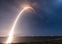
On June 24, the US and Taiwan are scheduled to launch a coterie of six small satellites that will orbit tropical latitudes. The satellites, a joint project of the US National Oceanic and Atmospheric Administration (NOAA) and the Taiwan National Space Agency, will provide more frequent high-resolution data about temperature, pressure, and water vapor, improving tropical-storm forecasts. The project, called COSMIC-2 in the US and FORMOSAT-7 in Taiwan, will also provide an unprecedented level of detail about the planet’s ionosphere. This upper level of the atmosphere is a swirl of electrons and ions, blasted by the sun and adjacent to the Earth’s magnetosphere. So far, atmospheric scientists have had limited tools for monitoring this region. Previous satellite and ground-based systems provided infrequent, low-resolution data about the ionosphere. COSMIC-2 will continuously monitor the electron density of the ionosphere from 40° north of the equator to 40° south, tracking how charges move and potentially enabling predictions of space weather. “We’re not getting this data from any other source,” says Elsayed Talaat, an atmospheric scientist who directs NOAA’s Office of Projects, Planning, and Analysis. He says the agency hopes this continuous monitoring will help predict magnetic and electrical disturbances that can interfere with air traffic and the electrical grid.


Join the conversation
Contact the reporter
Submit a Letter to the Editor for publication
Engage with us on Twitter